Satellite images reveal damage to Iran’s nuclear and military sites, raising geopolitical risk for crypto markets
Commercial satellite imagery confirms extensive strikes on Iranian nuclear infrastructure, adding another variable to an already volatile macro environment for risk assets.
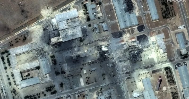
Commercial satellite imagery has confirmed extensive damage to multiple Iranian nuclear and military facilities following US and Israeli airstrikes. The images, captured by providers including Maxar Technologies (now Vantor) and Planet Labs, show craters, destroyed buildings, and debris fields across some of Iran’s most sensitive nuclear sites.
What the satellites captured
Satellite images dated March 1-2, 2026, reveal extensive destruction at the Natanz uranium enrichment complex, including demolished personnel buildings and wrecked vehicle access points leading to underground enrichment areas.
The Fordow enrichment facility took hits from bunker-buster munitions, with visible craters and debris confirmed by imagery from June 24, 2025. Additional Israeli strikes damaged access routes and tunnels at the site.
The Isfahan Nuclear Technology Center shows widespread infrastructure destruction from targeted strikes, with June 2025 imagery confirming the precision of the attacks. Satellite footage from March 2026 also documented significant impacts at the Taleghan nuclear test facility, again showing evidence of bunker-buster use.
Beyond nuclear sites, the Choqa Balk-e drone facility and radar systems at the Zahedan airbase were also visibly damaged. Analyses from BBC Verify, AP, and the Institute for Science and International Security suggest that while Iran’s nuclear infrastructure suffered significant setbacks, the country’s nuclear program remains intact, suggesting materials may have been moved away from targeted sites before the strikes landed.
The bigger picture
The before-and-after imagery spans from March through June of 2025 and into 2026, indicating this wasn’t a single operation but a sustained campaign across multiple facilities. The satellite imagery provides public visual evidence confirming damage at what were previously secret nuclear sites.